Sign up for the Morning Brief email newsletter to get weekday updates from The Weather Channel and our meteorologists.
Talk about a winter full of oddities.
“On Wednesday, the self proclaimed ‘Icebox of the Nation,’ International Falls, Minnesota, reached 50 degrees for the first time in January in records dating to 1897,” weather.com senior meteorologist Jon Erdman notes.
Another eye-popping stat picked up by Erdman: Tuesday was warmer in southern Saskatchewan, Canada, than it was in Key West, Florida.
We sat down with our team of expert meteorologists, including Erdman, to chat about what they’re watching most closely in the weather this weekend and beyond, as winter lumbers toward its end.
Rain more than snow seems to be the story for many parts of the U.S. this winter - and this weekend. What weather are you watching most closely?
Linda Lam - The weather this weekend definitely has an El Niño feel with plenty of moisture across the southern tier and warmer-than-average temperatures in the northern tier. Powerful storms in California are often associated with El Niño and we will see another potent storm approach the Golden State on Sunday. The details with this next system are in question so I’ll be watching closely to see how much of a flood threat there will be into next week.
Chris Dolce - California will also be upfront in my mind, but another thing that’s interesting about this weekend’s weather is how the Northeast and South will trade places. Cities from Boston to New York and Philadelphia will enjoy a mostly sunny weekend on the heels of a more than week-long cloudy stretch. Meanwhile, several cities in the South will swap what has been a mostly dry week with some sunshine for rain and increased cloudiness, from the Gulf Coast to Georgia and Florida.
February’s already upon us, which means a wide variety of weather. What can we expect this month?
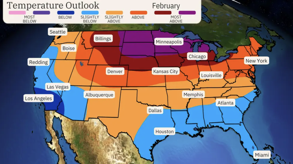
Linda - February can be a very interesting weather month as snow is often plentiful but temperatures begin to warm. The snowiest month on average is February for many locations in the Northeast, Plains and West. The mild trend to start the month will limit snowfall but there are signs that a pattern change in the middle of the month could make the second half a bit more interesting.
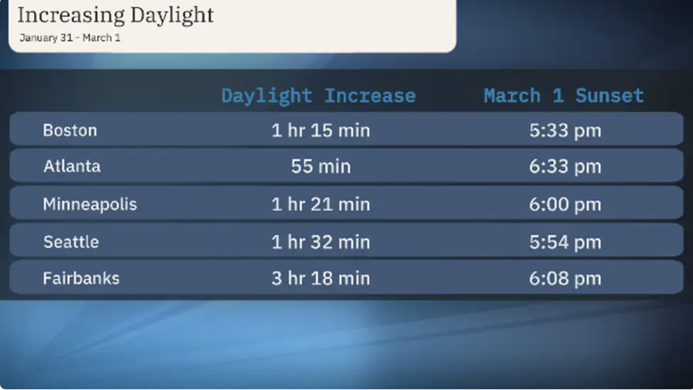
Chris - It’s not weather per se, but one aspect of February I’m looking forward to is the increase in daylight through the month, which is the big tease that spring is getting closer and closer. Sunset will be just after 6:30 p.m. in Atlanta, 6:00 p.m. in Minneapolis and just after 5:30 p.m. in Boston by the end of the month. As a lover of the outdoors, that’s something I’m really looking forward to, as well as the arrival of Daylight Saving Time in early March.
February also signals that, meteorologically, winter is barreling toward its end. What’s stood out to you so far this season?
Jon - It’s hard to believe we’re two months through the three-month “meteorological winter.” You wouldn’t know it if you asked typically shivering people in Minnesota and North Dakota. It’s been the warmest winter-to-date (through January) on record in the Twin Cities; Fargo, North Dakota; and the previously mentioned International Falls, Minnesota. A mere 2 inches was the deepest snow cover Minneapolis-St. Paul Airport has managed this entire season, and that happened on Halloween! By one measure, the Twin Cities has had its least miserable winter, so far, since at least 1950.
Chris - The dramatic flip we saw from the warmest December on record in the Lower 48 to a series of winter storms and brutally cold arctic air in the first half of January stands out most prominently to me so far. Those storms, which came in rapid succession, produced a variety of weather, from blizzard conditions and tornadoes to flooding rain, high winds and serious coastal flooding. Then, just like that, the pattern flipped again in late January, bringing warmer than average temperatures and the feel of early spring to northern parts of the country that were just shivering.
What else is on your radar?
Jon - We’ve reached the peak time of year for major Northeast snowstorms. However, the southern soaker Linda alluded to earlier is not expected to become a Northeast storm. So, the January thaw which has shattered record highs in the U.S. and Canada will become a February thaw for a while. There is that potential for a mid-month pattern change that, together with the current strong El Niño, could make for more interesting winter weather in the latter half of the month. But all those details are still to be determined during what can be a particularly exciting month for weather in the U.S.
MORE ON WEATHER.COM
-What To Expect In February Weather
-What Is An Atmospheric River?
-Mild Winter Contributes To Deaths From Falling Through Ice
Weather.com reporter Jan Childs covers breaking news and features related to weather, space, climate change, the environment and everything in between.
The Weather Company’s primary journalistic mission is to report on breaking weather news, the environment and the importance of science to our lives.


